Saturday, June 16, 2012


Old_Harry_Rocks.jpg
This photograph show many coastline features that are cause by the erosion of the sea. The stacks, caves and arches are all caused by waves being refracted around the tip of the point and back into the base.

matterhorn.jpgThis is the famous Matterhorn mountain, its distinguished horn is formed by aretes and sevres. These edges and pools are formed by a receding glacier.

Wednesday, June 13, 2012

Barometer


http://meanbailey.com/images/barometer2.jpg                               This is a barometer. It is used in meteorology and used to atmospheric pressure. It can help find surface troughs, high pressure systems, and frontal boundaries.
EARTHQUAKE!!

 A magnitude-9.0 earthquake struck off the coast of Japan on March 11, 2011 which in turn resulted in tsunamis.  Humans all over the world are still feeling the effects of this massive earthquake, even here in Victoria where debris from the quake and tsunamis is being washed upon our shores.

Post #12 Air Photo/Satellite Image

 Human Geographers may use this image to their advantage and go for a vacation to this white sand, tropical looking place! This air photo doesnt have much detail but it shows how wonderful this little getaway would be! Enjoy :)


Post #11 Biomes

The Drip Tip leaf is an adaptation of Flora in the Biome of the Tropical Rainforest.  The drip tip is designed for the leaf to shed the water that may land on it.  Due to the mass amounts of water that falls in this biome the drip tip helping the water get off the leaf and down to the lower ground to help water the plant.
 

Monday, June 11, 2012

Post #10 Global Warming

The sea ice is melting in the colder regions due to global warming and the warming of the climate is effecting the temperature of the sea water which also increases the melting pace of the Ice sheets which are also known as Ice Burgs.  The sea ice melting will impact humans at a later date because if all the ice burgs melt that means that that much more ice that has melted into water will now have no where to go but into the shores and there for created less land for us humans to live on.  Once that water has engulfed that much more shore and with how our economy is vasly growing there will be a much greater struggle for everyone to find a home in the places they may wish.

MT VESUVIUS.
 
 This Volcano is called Mt. Vesuvius and it has been inactive for 60 years.  It is located in pompei Italy.  If Mt. Vesuvius erupted today the catastrophe would be massive, as the surrounding area has a population of 555,000 people.  Mt. Vesuvius is one of the worlds most well known composite volcanoes. 

Post #9 Acid Rain

In this photo is a gargoile that has started to be effected by acid rain!  Over time the rain has deteriorated the cement that this statue has been made up of.  It's been said that if you carpool it helps stop the creation of acid rain.

Dosiero:- Acid rain damaged gargoyle -.jpg

Monday, May 14, 2012

Mount St Helens volcano - They use for alert people around the volcano when it will start the activity.

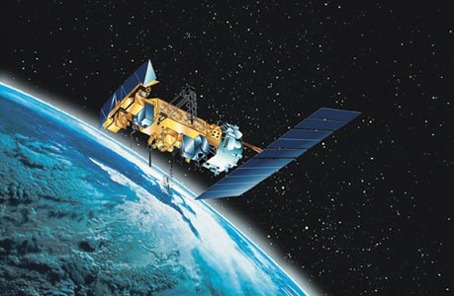
helps people see nifty stuf
This is an oblique air photo of the September 11th attack. An oblique air photo is a type of air photo. It is not like your typical straight-vertical style of a birds eye view. It is taken from a certain angle. As you can see, this picture shows the layers of smoke as they travel in between the buildings and around New York City as the twin towers/World Trades Center fall.

9/11

The photo above is of the World Trade Centers after getting struck by the Planes. It shows the smoke coming up off the buildings before collapsing. This could provide good insight to those generations to come as to how big the catastrophe was. The second image is of after the 9/11 incident and everything got cleared away. It looks haunting.
Somehow in Southern America satellites found a mountain formation that is in the shape of and Aztec mans face. This spectacle can only be seen from outer space.

Biome

 
Bears live in deciduous forests. They hibernate in winters and have thick furs to keep themselves warm.
http://starchild.gsfc.nasa.gov/Images/StarChild/solar_system_level2/mars_rivers_big.gif
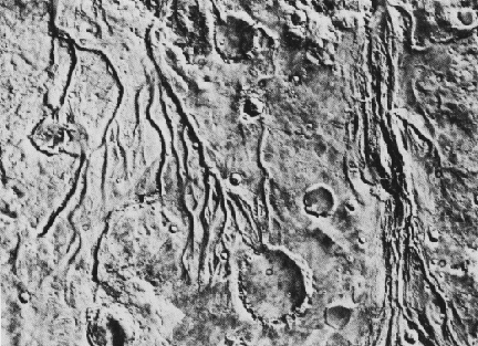
This is a satellite image of river systems on the surface of Mars. It helps Martian geographers determine that  there was once water on Mars.

Icelandic volcano eruption

This was the 2011 eruption in Iceland. Geographers would use this image to determine the approximate size and impact of the eruption. Potential impacts include shutting down flights across Europe, evacuation and inability to obtain certain commodities. As well, with large eruptions, the dust in the air grows so dense that the sun cannot breach through to provide sunlight for the area. This can impact the agriculture enormously.

This is a photo of the Eiffel Tower it was taken by a satellite. Geographers can use this satellite image to learn what surrounds famous structures and help understand the different fauna and flora that inhabits Paris. 

sattilite of tsunami buddz


In this photo, geologists can use this phone to determine how far the water went inland, they can also use this image to approximate the damage caused by the tsunami including building damage and more. This is a great before and after image of the devastating Tsunami that stuck Sri Lanka On December 26, 2004, tsunamis swept across the Indian ocean, spawned by a magnitude 9.0 earthquake off the coast of Sumatra. 

satelite things

This is a picture taken by a satellite of a valcanoe erupting, satelites can track the ash as it blows across continents and inform news stations to send out warnings.